A school closure, roads blocked, and a rescue: Sonoma County deals with effects of latest atmospheric river
Motorists looking to reach Windsor via Shiloh Road off of northbound Highway 101, Friday morning, will have to find another way.
The offramp is one of many roadways closed by standing water as a result of the atmospheric river that began falling Thursday afternoon in the North Bay.
According to the California Highway Patrol’s traffic website, Caltrans shut down the exit ramp. A vehicle was left there overnight due to the flooding and no other vehicles will be able to get through, according to a post on the CHP site, made shortly before 6:30 a.m.
Also, schools in the Guerneville School District will be closed Friday, according to the Sonoma County Office of Education. Nearby creek flooding is affecting its parking lot and nearby roads, officials said.
Numerous roadways across Sonoma County have been affected by the rains, which have already tapered off Friday morning.
A woman whose car was trapped in standing water Thursday night on Trenton-Healdsburg Road near Riverfront Regional Park was saved by a swift water rescue crew from the Forestville Fire Department, which is part of the Sonoma County Fire District.
If not inundated by standing water, some roads were affected by debris or downed trees.
Green Hill Road, between Graton and Occidental, was blocked by a mudslide Thursday afternoon that was reported just after 4:30 p.m.
Crews were able to clear one lane so motorists could pass.
In Rohnert Park, shortly after 5:30 p.m., city workers closed off a portion of Rohnert Park Expressway near Stony Point Road due to flooding.
And, just before 5:50 p.m., according to the California Highway Patrol traffic website, there were reports of a downed tree blocking the westbound lanes of Highway 116, just west of Mirabel Road.
At about that same time, authorities received reports of hydroplaning cars along Hall Road near Park Royal Avenue in northwest Santa Rosa. According to the CHP website, there was 6 inches of water in the roadway.
Meteorologists predict some areas of the North Bay could see up to 8 inches of rain through Friday night, depending on the terrain and where thunderstorms hit.
Santa Rosa is expected to get about 2 to 3 inches of rainfall.
The warm atmospheric river started moving through the area in the early afternoon. It is expected to flow south and eventually clear San Francisco around 10 p.m., said Evan LaGuardia, a National Weather Service meteorologist.
Atmospheric rivers, long and narrow bands of moisture in the atmosphere, transport water vapor and warm air from the tropics, according to the weather service. Typically they extend for thousands of miles and dump rain and snow when they make landfall.
By Thursday evening, the storm was expected to drop light to moderate rain in Sonoma County. It would get gradually heavier into the night, with a 30% chance of thunderstorms.
During the thunderstorms, rain rates could reach up to 2 inches per hour, LaGuardia said.
Sonoma County maintains this list of emergency shelters that are open for people who are homeless and seeking relief from the cold and rain.
The weather service issued a flood watch for the entire Bay Area and Central Coast through 10 a.m. Sunday, and a wind advisory will be in effect until 4 p.m. Friday.
Strong southerly winds of 35 to 39 mph are expected at elevations below 900 feet with gusts of 47 to 57 mph possible, according to the weather service.
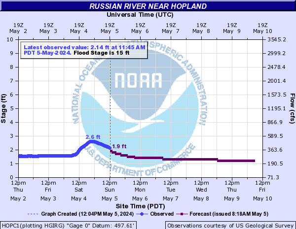
According to a graph released by the California Nevada River Forecast Center, operated by the National Oceanic and Atmospheric Administration, the Russian River was forecast Thursday afternoon to reach up to a foot above the flood stage of 15 feet in Hopland around 8 a.m. Friday.
In Guerneville, the river was forecast to crest Friday evening a little over a foot above the 32-foot flood stage before receding Saturday morning. There is significant margin of error in the forecasts.

The consistent rainfall and heavier storms will slow about 11 a.m. Friday, though rainfall could continue Friday night into Saturday.
Because of the warmth of the storm, which originates in the Hawaiian islands, there will most likely not be snow outside of points around 8,000 feet in the Sierra Nevada mountain range.
Staff Writer Jeremy Hay contributed to this report.
You can reach Staff Writer Madison Smalstig at madison.smalstig@pressdemocrat.com. On Twitter @madi.smals.
UPDATED: Please read and follow our commenting policy: